With a whisper we find out that city staff have a two week extension to wrap up the last of the negotiations and sign the contract with PBSC (which operates BIXI). Kudos to BlogTO for following up with city staff:
Daniel Egan, City of Toronto manager of pedestrian and cycling infrastructure, told me over the phone that "BIXI has essentially met all the milestones, but the sponsorship deadline was extended by a couple of weeks to finalize some of the details." That's why there hasn't been a formal announcement -- the program isn't actually officially a go until this happens. But, regardless of this slight extension, Egan confirmed that the May 2011 "launch date remains the same."
They like to keep things to themselves: even the bike advocacy community leaders in Toronto were not told about the extension. I was under the assumption that we would be hearing the news by today. Either way, this leaves us cautiously optimistic. We may win this battle, just as Mayor Ford declares the end of the "war on the car" (I guess that means we should put away the IEDs). Apparently he hasn't received the memo that the world has now passed "peak oil" back in 2006. I wouldn't break open the champagne too early Ford. You may have to start fighting the war on reality.
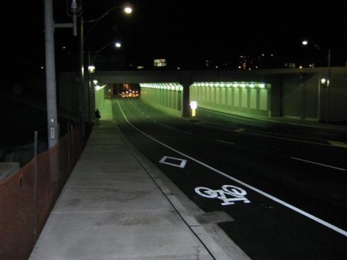
![Mon, 11/22/2010 - 10:19 - Nov. 22, 2010, 9:19 a.m. Runners often use tunnels to negotiate their way under busy roads and railway lines (see other examples: #one; #two; #three), but few roadway tunnels are this nice, and I ran through it just days after the official opening. Below is a news story about the new Dufferin Street tunnel, from Toronto's Globe & Mail newspaper.</p>
<p>[See the “LARGE” version of this photo.]<br />
----------------- </p>
<p>'Eliminating the Dufferin Jog: ‘Gravy’ – or good planning?'<br />
by Kelly Grant, City Hall Bureau Chief, Globe and Mail<br />
Nov. 17, 2010 </p>
<p>It’s Toronto's largest non-transit infrastructure project in the past few years, and one the city has been waiting for since the 19th Century.</p>
<p>A new 70-metre tunnel connecting Dufferin Street beneath the rail bridge at Queen Street officially opens at 3 p.m. on Thursday, freeing motorists and some 40,000 weekday bus passengers from the despised “Dufferin Jog” down Peel and Gladstone avenues.</p>
<p>But (Mayor) David Miller’s government opted to go beyond erasing the jog: It built an amphitheatre on the north side of Queen Street west of Dufferin Street, installed new light standards and replaced chain link with decorative fencing. Plantings, attractive metal cladding and underpass murals will be installed next spring.</p>
<p>“Instead of a typical dreary infrastructure project, we turned it into an exercise in place-making,” said Gord Perks, the councillor for Ward 14 Parkdale-High Park. “Some might call it gravy. I say not.”</p>
<p>Although the project came in on budget, remaking the gateway to Parkdale is the kind of optional undertaking that might not fly under Rob Ford, the new mayor Torontonians picked for his low-budget, back-to-basics philosophy. Just up the road from the new underpass, for example, Dufferin is a scarred and pitted mess.</p>
<p>It’s difficult to predict whether the Ford administration would put filling such potholes ahead of the artistic touches on the new Dufferin underpass.</p>
<p>Mr. Ford set aside up to $400-million for “fixing disjointed” streets in his transportation plan, but he has also vowed to axe the vehicle-registration and land-transfer taxes whose revenues help pay for such projects.</p>
<p>As well, Councillor Mike Del Grande – a Ford supporter rumoured to be in line for a senior post, possibly budget chief – tried during council’s capital budget debate in December 2008 to kill the Dufferin Jog elimination and direct the money elsewhere. The speaker ruled his motion out of order because the project was already approved and under way.</p>
<p>Neither Mr. Ford nor Councillor Case Ootes, the head of his transition team, would comment.</p>
<p>Unlike some other high-profile city construction projects, the Dufferin Jog elimination was completed within its $40-million budget, according to Jim Schaffner, a city engineer and the project manager.</p>
<p>That breaks down to $8-million for property acquisition, $6-million for work on the rail corridor and $26-million for constructing the underpass.</p>
<p>However, the project, which began in December 2008, is far from on time. “We should have been finished in January of this year,” Mr. Schaffner said. “As you can tell, we’re obviously quite a bit behind.”</p>
<p>Mr. Schaffner blamed the delay on the discovery of a previously unknown fibre-optic cable and the tougher-than-expected replacement of the frame that carries the rail bridge, which was lifted and put on a temporary trestle.</p>
<p>Shifting the bridge so trains could keep running for most of the construction period was a delicate engineering job. Re-installing it was “almost like building a Swiss watch,” Mr. Schaffner said.</p>
<p>The traffic clot at Dufferin and Queen thickened during construction, but the obstruction didn’t prompt an outcry from business owners.</p>
<p>Robert Sysak, the administrator of the West Queen West Business Improvement Area, said none of his member businesses approached him with complaints about the construction. Most were just eager to see artery cleared.</p>
<p>The general manager of the nearby Gladstone Hotel agreed.</p>
<p>“We’re really excited,” Alec Badley said. “The big thing we really want to see once this is done is the redevelopment of Gladstone Avenue.”</p>
<p>Right now, Peel and Gladstone avenues are run-down streets choked with traffic, including some 31 buses arriving every three minutes on weekdays on the TTC’s fifth-busiest bus route.</p>
<p>Now that buses and cars will be able to use the tunnel, the plan is to narrow Gladstone to a landscaped, pedestrian-friendly one-way street north of the Price Chopper, according to outgoing Councillor Adam Giambrone, who represents the area north of Queen Street until Nov. 30.</p>
<p>“It took six years of concerted work and it’s a project that’s been on the books for 125 years so it feels pretty good to finally see it opening,” he said.<br />](https://live.staticflickr.com/5046/5200064589_750f31003e_z.jpg "Mon, 11/22/2010 - 10:19 - Nov. 22, 2010, 9:19 a.m. Runners often use tunnels to negotiate their way under busy roads and railway lines (see other examples: #one; #two; #three), but few roadway tunnels are this nice, and I ran through it just days after the official opening. Below is a news story about the new Dufferin Street tunnel, from Toronto's Globe & Mail newspaper.</p>
<p>[See the “LARGE” version of this photo.]<br />
----------------- </p>
<p>'Eliminating the Dufferin Jog: ‘Gravy’ – or good planning?'<br />
by Kelly Grant, City Hall Bureau Chief, Globe and Mail<br />
Nov. 17, 2010 </p>
<p>It’s Toronto's largest non-transit infrastructure project in the past few years, and one the city has been waiting for since the 19th Century.</p>
<p>A new 70-metre tunnel connecting Dufferin Street beneath the rail bridge at Queen Street officially opens at 3 p.m. on Thursday, freeing motorists and some 40,000 weekday bus passengers from the despised “Dufferin Jog” down Peel and Gladstone avenues.</p>
<p>But (Mayor) David Miller’s government opted to go beyond erasing the jog: It built an amphitheatre on the north side of Queen Street west of Dufferin Street, installed new light standards and replaced chain link with decorative fencing. Plantings, attractive metal cladding and underpass murals will be installed next spring.</p>
<p>“Instead of a typical dreary infrastructure project, we turned it into an exercise in place-making,” said Gord Perks, the councillor for Ward 14 Parkdale-High Park. “Some might call it gravy. I say not.”</p>
<p>Although the project came in on budget, remaking the gateway to Parkdale is the kind of optional undertaking that might not fly under Rob Ford, the new mayor Torontonians picked for his low-budget, back-to-basics philosophy. Just up the road from the new underpass, for example, Dufferin is a scarred and pitted mess.</p>
<p>It’s difficult to predict whether the Ford administration would put filling such potholes ahead of the artistic touches on the new Dufferin underpass.</p>
<p>Mr. Ford set aside up to $400-million for “fixing disjointed” streets in his transportation plan, but he has also vowed to axe the vehicle-registration and land-transfer taxes whose revenues help pay for such projects.</p>
<p>As well, Councillor Mike Del Grande – a Ford supporter rumoured to be in line for a senior post, possibly budget chief – tried during council’s capital budget debate in December 2008 to kill the Dufferin Jog elimination and direct the money elsewhere. The speaker ruled his motion out of order because the project was already approved and under way.</p>
<p>Neither Mr. Ford nor Councillor Case Ootes, the head of his transition team, would comment.</p>
<p>Unlike some other high-profile city construction projects, the Dufferin Jog elimination was completed within its $40-million budget, according to Jim Schaffner, a city engineer and the project manager.</p>
<p>That breaks down to $8-million for property acquisition, $6-million for work on the rail corridor and $26-million for constructing the underpass.</p>
<p>However, the project, which began in December 2008, is far from on time. “We should have been finished in January of this year,” Mr. Schaffner said. “As you can tell, we’re obviously quite a bit behind.”</p>
<p>Mr. Schaffner blamed the delay on the discovery of a previously unknown fibre-optic cable and the tougher-than-expected replacement of the frame that carries the rail bridge, which was lifted and put on a temporary trestle.</p>
<p>Shifting the bridge so trains could keep running for most of the construction period was a delicate engineering job. Re-installing it was “almost like building a Swiss watch,” Mr. Schaffner said.</p>
<p>The traffic clot at Dufferin and Queen thickened during construction, but the obstruction didn’t prompt an outcry from business owners.</p>
<p>Robert Sysak, the administrator of the West Queen West Business Improvement Area, said none of his member businesses approached him with complaints about the construction. Most were just eager to see artery cleared.</p>
<p>The general manager of the nearby Gladstone Hotel agreed.</p>
<p>“We’re really excited,” Alec Badley said. “The big thing we really want to see once this is done is the redevelopment of Gladstone Avenue.”</p>
<p>Right now, Peel and Gladstone avenues are run-down streets choked with traffic, including some 31 buses arriving every three minutes on weekdays on the TTC’s fifth-busiest bus route.</p>
<p>Now that buses and cars will be able to use the tunnel, the plan is to narrow Gladstone to a landscaped, pedestrian-friendly one-way street north of the Price Chopper, according to outgoing Councillor Adam Giambrone, who represents the area north of Queen Street until Nov. 30.</p>
<p>“It took six years of concerted work and it’s a project that’s been on the books for 125 years so it feels pretty good to finally see it opening,” he said.<br />")