The Cycling in Cities program at the University of British Columbia has published the results of their ambitious study and revealed that bike lanes and quiet streets make cycling safer, but that separated bike lanes (cycle tracks) provide the most safety. In their study of 690 injured cyclists in Toronto and Vancouver who ended up in emergency rooms, they've found that bicycle infrastructure had a positive effect on cycling safety. Not surprisingly people prefer bike lanes, bike paths and quiet streets to just regular roads (as discovered their earlier study).
The researchers also found that major streets with on-street parking were the riskiest streets for cyclists, and particularly for Toronto cyclists, major streets with on-street parking and streetcar tracks.
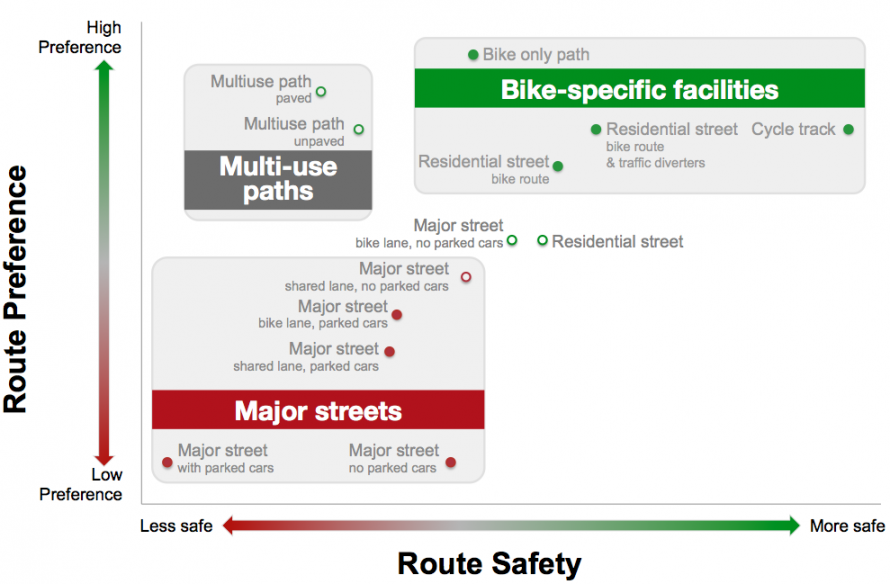
We found that route infrastructure does affect the risk of cycling injuries. The most commonly observed route type was major streets with parked cars and no bike infrastructure. It had the highest risk. In comparison, the following route types had lower risks (starting with the safest route type):
- cycle tracks (bike lanes physically separated from motor vehicle traffic) alongside major streets (about 1/10 the risk)
- residential street bike routes (about 1/2 the risk)
- major streets with bike lanes and no parked cars (about 1/2 the risk)
- off-street bike paths (about 6/10 the risk)
The following infrastructure features had increased risk:
- streetcar or train tracks (about 3 times higher than no tracks)
- downhill grades (about 2 times higher than flat routes)
- construction (about 2 times higher than no construction)
The Toronto Star's story focused exclusively on the danger of streetcar tracks, but they missed the bigger story that it's not just the streetcar tracks but parked cars that make things particularly dangerous for cycling. Not only does Toronto have few alternatives to streetcar streets downtown, almost all of them allow car parking for most of the day, thus providing only a very narrow comfortable space between parked cars and streetcar tracks. Even though streetcar tracks are involved in a third of cycling injuries, half of those injuries were the result of parked cars:
Motor vehicles were involved in many injury events beyond direct crashes. For example, nearly half of crashes involving streetcar tracks involved maneuvers to avoid double-parked cars or cars moving in or out of parking spots.
It's highly possible that the danger of streetcar tracks can be mitigated in Toronto by removing on-street parking and providing bike lanes (or at the least sharrows). The researchers may have found much different results if that were the case.
The same researchers are applying their research to improving cycling education. For instance, no cycling courses currently cover route selection even though studies have shown that bicycle infrastructure make people safer. They also recommend that cycling education begin to cover the circumstances when motor vehicles are likely to pass closely. Their recommendations were to:
Include information about the relative safety of route types and route characteristics to help cyclists plan their routes, in particular:
- decreased risk associated with bike-specific route types, including cycle tracks, bike lanes, and bike paths,
- decreased risk associated with routes with low traffic volumes, including residential street bike routes,
- increased risk associated with roundabouts or traffic circles at intersections, and
- increased risk after dark on routes without streetlights.
Include information about motor vehicle passing distances, so cyclists understand circumstances when motor vehicles are likely to pass closer to them, in particular:
- where motor vehicle speeds and traffic are high,
- where there is motor vehicle traffic in the opposing direction, and
- when the passing vehicle is a heavy vehicle such as a truck or bus