It appears as if work on the separated bike lanes on Wellesley and Harbord has been slow and it's unclear if the City will meet its timeline. Transportation Services has been working on the initial phase of Wellesley but they haven't gotten far enough in either project to meet the target dates.

City Staff was directed last year, June 2011, by the Public Works and Infrastructure Committee (PWIC) to "proceed with the detailed design and consultation process for developing separated bicycle lanes on Wellesley Street with the goal of implementing them in 2012".

City staff was also directed by PWIC to start working on Harbord - Hoskin and Beverley to report in May this year:

City Council direct the Acting General Manager, Transportation Services, to commence the design phase for separated bike lanes on Harbord - Hoskin and Beverley that includes community and stakeholder consultation and consideration of the availability of parking on local side streets, with a report back to the May 2012 meeting of the Public Works and Infrastructure Committee.

This year, at the April 18, 2012 PWIC meeting, PWIC requested an update on Wellesley. We will get the official update at the May meeting. I spoke with Christina Bouchard of Transportation Services who told me that they have been doing "counts, parking surveys and traffic analysis along Wellesley, and have met with the Councillor" but that they haven't prepared any public consultation meetings as of yet. Given this pace it appears that the probability of constructing the separated Wellesley Street bike lanes in 2012 is remote.

Hopefully City Staff has advanced the design work for physically separated bicycle lanes on Harbord, Hoskins and Beverley Streets as they were directed a year ago. I haven't received any information on the progress, but given the pace of Wellesley it's likely that these streets will be even later. Anyone interested should monitor the agenda of PWIC for its May 16, 2012 meeting.

The Ward groups of wards 19, 20, 27 and 28 have become concerned regarding the slow pace and have sent a letter to PWIC (pdf) to suggest a number of improvements to the process. The letter strongly supports the separated bike lanes on Wellesley, Harbord-Hoskins and Bevereley. In addition it supports the improvements suggested by Councillor Vaughan for Ward 20. It also suggests that City Council expand the scope of planning for Wellesley to include the bikeway from Ossington to Parliament.

Evergreen Brick Works will be hosting their inaugural charity bike ride “Ride the Ravines” on Sunday, June 17, in support of accessible cycling in the GTA. Riders of all levels are welcome! Register today!

Ride the Ravines will take riders through Toronto's ravine network, residential streets, a major road, the lakeshore boardwalk, and a few parks. The route begins and ends at Evergreen Brick Works, and is 25km in total (with the option of a shorter 12km route as well). This will be a fun mass ride weaving through parts of the City you've never seen.

After the ride, cyclists and community members will come together for our after-party at Evergreen Brick Works – a vibrant, fun-filled event featuring live musical acts, delicious food, and an opportunity to mingle with sponsors, retailers, and community partners (including ING Direct, Cycle Toronto and yours truly, I Bike TO).

Hope to see you there!

Poster is below in case you would like to print it off.

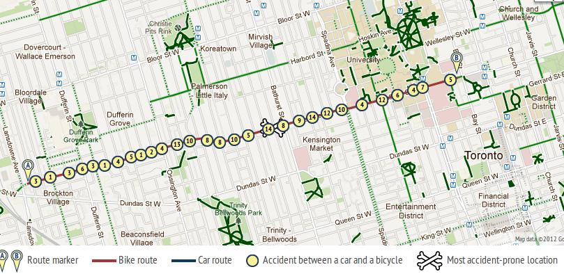
OpenFile has a young and bike-friendly group of journalists writing and researching for it. It has just produced a pretty cool map of traffic "accidents" called OpenRoad where people can choose start and end points of a journey to see the number of crashes along the way that were reported to the police. (I'm going to stick to calling them crashes since we don't know if they were actually accidents or if they could have been prevented). The Globe and Mail created a similar map not too long ago, using the same / similar data. I wrote up my criticisms of that map and most of the same criticisms stand for OpenRoad. OpenFile, in this initiative, is misleading the public more than they're helping. They've failed to provide context for the numbers and the whole project implies that they are helping people find the most dangerous intersections.

OpenFile is aware of the problem with the data and notes that "A route with more accidents isn't necessarily more dangerous for each individual on it." Popular cycling routes will inevitably have more crashes than routes where no cyclists venture. Their map is unable to tell us why an intersection has lots or few crashes. Is it because it gets used a lot by cyclists? Or does it have bad sightlines, heavy traffic, or lots of potholes? We have no idea based on their map.

It begs the question of the usefulness of the map at all if we can't even use it to help us make decisions on our routes.

With the one hand OpenFile explained the limitations of the OpenRoad map, but with the other hand they were exploiting it for headlines like "MONTREAL'S MOST DANGEROUS INTERSECTION FOR CYCLISTS" and a tamer headline "Vancouver’s intersection with the most bicycle-vehicle collisions", which still contained the statement "It will come as no surprise that Main Street at East 2nd Avenue, a hub of both bikes and cars, is the most dangerous cycling intersection in Vancouver with 10 accidents reported to police between 2007 and 2010".

No, that's not how it works.

The media now seems to be more interested in playing with cool new tools rather than consult with experts - in this case bike safety researchers - in order to understand how we can actually measure "safety" and "danger".

We don't have good cycling counts in Toronto. The best we have is the Downtown Cordon Count from 2010 but it will serve the purpose for my argument. Let's compare College and Dundas. The report counted the number of cyclists passing a cordon over the day and the western boundary was Spadina. Using the OpenRoad map I selected a route on College from Bathurst to Beverley and the same from Dundas. I then can make a rough comparison of crashes to the cyclist counts on these two streets.

Street Cyclists (per day) Crashes (2007-2010)
College 4722 65
Dundas 1394 30

There are 3 times as many cyclists on College as Dundas, but only 2 times as many crashes. (I am making what I think is a safe assumption that cycling traffic on College tends to always be about 3 times as high as Dundas). From the viewpoint of an individual cyclist which street would you think would mean less risk of a crash? Going by the OpenRoad map and headlines I would venture that OpenFile would proclaim Dundas as the safer street and College as more dangerous. College has twice as many crashes after all. But as soon as we take into account how many cyclists are actually travelling on these two streets College starts to look a lot better than Dundas.

Ideally in such investigative journalism it would be nice to have a map like this, which maps the pedestrian collisions with a denominator of pedestrian traffic. But we can't get that. So what is the point of OpenRoad?

OpenFile and the Globe and Mail have, at best, just provided yet another fun-looking but pointless widget, and, at worst, helped to persuade people to choose cycling routes that are actually more dangerous than their tool would tell them. Anyone up for biking on Steeles? It has a heck of a lot fewer crashes than College Street.