The proposal for the "pedestrianization" of the John Street "Cultural Corridor" remake has been finalized and will be voted on by the Public Works and Infrastructure Committee meeting this Thursday Feb 16 and then on to City Council. There are no bike lanes in the proposal despite John Street being a quite popular connection for cyclists to and from downtown. It seems to me that some kind of bike lanes - out of pain or decorative bricks could have been an easily accommodated while still allowing for a much improve pedestrian realm.
The John Street plan looks quite nice. I look forward to seeing it completed. It's laudable that a downtown street will be made more livable by making motor vehicles less dominant. It's an important demonstration of moving away from fetishizing the private automobile, and towards a built environment friendlier to active transportation. But along the way the plan has devalued the role of cycling in creating a vibrant city.
The lack of cycling infrastructure is disappointing. There were a number of attendees to the open house who made requests for cycling infrastructure, but the planners decided they couldn't add any bike lanes because the street was recognized by City Council as a "pedestrian priority route" and claimed that bike lanes would interfere with their main goal:
The provision of bike lanes on John Street was arguably the most challenging and controversial aspect of this exercise. Clearly, the provision of bike lanes would reduce opportunities to expand sidewalks and improve the pedestrian environment which is the overall objective of this project. Nevertheless, throughout the public consultation process, submissions were made indicating a strong desire for the provision of bike lanes as part of
this reconfiguration. It was concluded, however, that with the recognition by City Council of John Street as a pedestrian priority route and the direction to enhance the pedestrian realm accordingly, the provision of bike lanes was not consistent with this direction. Furthermore, with the other transportation initiatives soon to be underway in this area, specifically the Downtown Transportation Operations Study and the Richmond/Adelaide Separated Bikeway Environmental Assessment Study, opportunities to improve cycling connections in this area on routes other than John Street will be developed.
The report says bike lanes would "reduce opportunities" to expand sidewalks, which I think would be best interpreted as "we didn't want to compromise our plan". By installing bike lanes the sidewalks wouldn't be quite as wide. The measurements made by Dave Meslin showed that John Street south of Queen was plenty wide to accommodate both wider sidewalks and bike lanes (from 1.2 to 3.8m). In the absence of any objective criteria from the planners on what is the ideal sidewalk width, it's not clear how they can outright exclude bike lanes as an option.
"Reducing opportunities" is not a good enough reason for waving aside the Toronto Official Plan which "states that an effort must be made to make all streets more bicycle friendly", notes planner Christian Chan in his submission to PWIC. "One of the provisions of the 2000 “Toronto at a Crossroads” Report and the Waterfront Plan is that traffic engineering and street design should encourage walking and cycling."
I strongly believe that a thorough assessment of the opportunity to include provisions for proper cycling infrastructure was not conducted, and the Study should not be considered completed until there is sufficient evidence presented by staff to support their position.
Chan suggested a simple designs that would help accommodate cyclists who will continue to use this key cycling route: "It has been established in the downtown pedestrian zones of Copenhagen, which shares many of the same features of the proposed pedestrian designs for John Street, that a simple surface texture change can guide the division of pedestrian traffic from cycling traffic in the proposed corridor." (A Toronto example of a textured bike lane would be the bike lane along St. George north of Wilcocks).
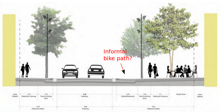
Make our own path?
I'm curious to see how cyclists will use John Street as imagined in this plan. In particular I am curious to see how cyclists will treat the unique space on the eastern side of the street called a "flexible boulevard". Will cyclists know that the planners meant it to extend the "pedestrian realm" and provide space for the "occasional delivery vehicle"? Or will they end up just using it as an informal bike path? And do the cyclists know that the "mountable curb" is there just for "emergencies"? I guess we'll see. Given the intentional permeability of the pedestrian and vehicular realms that we shouldn't be too surprised when cyclists start to filter more often into the pedestrian realm, particularly when there is no defined space for cyclists.
Why we should accommodate cyclists even on minor streets
There are four important reasons that we shouldn't ignore cyclists in the redesign of even on a minor street like John:
- It's a popular key route for cyclists to get to and from downtown.
- In order to be accessible cycling routes need to be comfortable for a wide range of abilities and ages.
- Bike lanes, and in particular separated bike lanes, provide a measure of safety (particularly on major arterial roads).
- Bike lanes help to keep drivers from drifting and blocking the space next to the curb where cyclists normally ride, thus making cycling faster on congested streets.
The report states "Although bike lanes are not included in the recommended design, with the narrowing of the pavement and the resulting calming of traffic, conditions for cyclists could arguably be better than the current situation." They are probably correct, though it doesn't address one of the biggest benefits of using cycling as an efficient mode of transportation: many more people can move through a smaller corridor by bike than by car. If John Street is clogged with cars it negates that benefit. I've often noticed on downtown streets with narrow lanes that cyclists can easily get stuck behind long lines of cars where if we just had a bike lane we'd easily beat all the cars.
The summary from the City's website:
The City of Toronto has completed the John Street Corridor Improvements Environmental Assessment Study, which resulted in the following Recommended Design:
The narrowing of the road pavement in order to provide significantly wider sidewalks and boulevard areas as follows:
From four to three lanes between Front Street and Wellington Street;
From four to two lanes between Wellington Street and Adelaide Street;
From three lanes to two lanes between Adelaide Street and Queen Street;
Exclusive right turning lanes northbound at Adelaide Street West and at Wellington Street West and a southbound left turn lane at Wellington Street West in order to maintain an adequate level of traffic service;
A continuous "mountable" curb on both sides of the street to enable a seamless transition into a pedestrian-only space for events, for vehicles to mount the flexible boulevard for deliveries or drop-offs, and to accommodate additional vehicular and cycling manoeuvring on either side of the road in emergencies;
The widening of the east side boulevard between Front Street West and Stephanie Street to provide a 2.5 metre wide flexible space (defined by bollards) to accommodate deliveries and, when not used for vehicular loading/unloading, for pedestrians; and
The provision of urban design elements which consist of a double row of trees where feasible, removable bollards, infrastructure to support special events and distinctive paving materials and patterns.
For further details, see the January 25, 2012 staff report, which includes imagery of the recommended design on pages 16 and 17.
http://www.toronto.ca/legdocs/mmis/2012/pw/bgrd/backgroundfile-44944.pdf
Additional drawings and other detailed study materials are available on the project web page under "Get Involved"
http://www.toronto.ca/involved/projects/john/index.htm#get
The City of Toronto’s Public Works and Infrastructure Committee (PWIC) will be considering the outcome of this study at its February 16, 2012 meeting, item PW12.3 (moved from Feb 15 because of a special Council meeting).
Sign up to depute at the PWIC meeting or leave your comments.