Toronto, like many North American cities, will need to tackle the suburban challenge when trying to make cycling more accessible to the average person. One way would be to make more efficient use of our major arterial roads such as Kingston Road. Kingston Road has a wide pointless median that could be removed to make room for cycle tracks on the edges without sacrificing precious road space for cars. That, however isn't going to happen in the short-term. And we'll still be left with many suburban neighbourhoods that are difficult to navigate by bike because they were purposefully built to make for difficult driving. Unfortunately this also makes it very difficult to walk or bike directly.
In a previous iteration of my life I commuted to York University and I found out quickly how taking side streets was a frustrating exercise. It required stopping to look at a map to find out how I could navigate the culs-de-sac and t-intersections of North York when trying to avoid having to ride on Keele Street where bikes are neither welcome nor expected.
Toronto could be exploring easy wins for the suburbs. One idea is to connect our culs-de-sac so we can remove barriers to accessible, healthy transportation. If we're starting with a blank slate there are ways to encourage these connections:
...zoning codes and ordinances should encourage connecting culs-de-sac with other transportation and neighborhood destinations. In some cases utility easements or alleys abutting culs-de-sac can be designed for double duty as multi-use paths, creating cross-town connections.
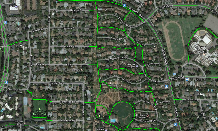
One community that was designed around connected culs-de-sac with great success is Davis, California (as seen in the image above). Most neighbourhoods, remarkably, have culs-de-sac which are connected to "linear parks" so that non-car trips have quick, direct access even while car trips require a more circuitous route. Yet, Toronto proper, has been mostly built-out and other than some limited quick wins it is much more difficult to do this with existing neighbourhoods.
An existing suburb of Portland, Oregon, Tigard, undertook crowdsourcing the mapping of quick wins. They asked the public to submit their "desire paths" through their town to find existing informal paths with no formal public access that can be improved and formalized. They then plan to build 42 miles of these connection among the neighbourhoods. "The city and its contractor, Kittelson & Associates, established a wiki-based web site where residents could indicate on a map where such informal walkways were." It's not clear how successful they were but it provided an interesting example of how other cities could improve their networks.
By the way, if you're not sure what a desire path is, it doesn't take much to find examples of them around you. A desire path, as defined by Nancy Friedman, is a "term in landscape architecture used to describe a path that isn't designed but rather is worn casually away by people finding the shortest distance between two points." Any trodden path will fit the criteria. Transportation planners should pay close attention: desire paths often point to problems with the officially sanctioned routes or lack thereof.
"A close look at any city park or green will typically reveal footprints that break away from paved walks, trails that countless pedestrians have worn into the grass. Such a trail is a desire path: the route people have chosen to take across an open place, making a human pattern upon the landscape." (Citing Lan Samantha Chang , in Home Ground: Language for an American Landscape, edited by Barry Lopez and Debra Gwartney.)
In my previous commutes to North York and to Mississauga I had to work hard (with mixed results) to find these desire paths which would reduce my time on the main streets with speeding, polluting vehicles. If you use Google's bike directions you will discover a wealth of short established connections (such as here or here). But they are scattered, only locals are likely to know about them, and there is no guarantee that you can string enough together to complete your route. Instead Toronto would need to take stronger actions:
In this scenario, bicycle/pedestrian connections must be carved out of private properties, streets, and rights-of-way. Municipalities have had success purchasing one or more affected properties, constructing a sidewalk or multi-use path between two culs-de-sac, and then re-selling the property. The City of Phoenix, Arizona, purchased and demolished a derelict property and constructed a multi-use path connection into an adjacent neighborhood.
What a different city it would be if Toronto had a well-marked network of short paths and residential streets that connect to cycle tracks on main arterial roads. People, young and old, could easily bike or walk across neighbourhoods to school, work, shopping, the playground.


