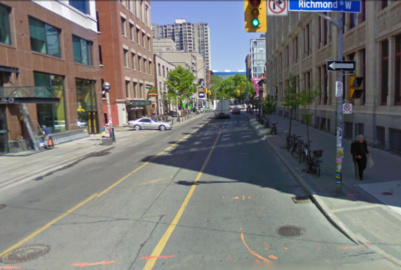
On John Street looking north towards Queen Street
This is the third of three posts about John Street and its place in the protected bike lane proposal by Councillor Minnan-Wong and the Bike Union (see first and second post). In the protected bike lane proposal John Street is the chosen connection between Beverley Street, which ends at Queen Street West, and Richmond Street, which will hopefully get protected bike lanes. Councillor Vaughan prefers Soho to Peter Street instead as part of his much smaller proposal so that John Street can be re-configured as a "cultural corridor", which has come to mean that there can be no accommodation of cyclists. John Street would be rebuilt to improve the pedestrian realm - a noble plan - and still allow bikes and cars.
I'd like to explain why John Street is a better street (and you don't need to just take my word for it, the Bike Union also explains why).
Soho/Peter forces cyclists to cross awkwardly in two stages at Queen Street; first a right, wait at lights, change lanes, and cross streetcar tracks and moving traffic all in a short distance. Even experienced cyclists have problems with streetcar tracks, particularly when changing lanes, where the tires can more easily get trapped in the groove, throwing cyclists off their bikes into traffic.
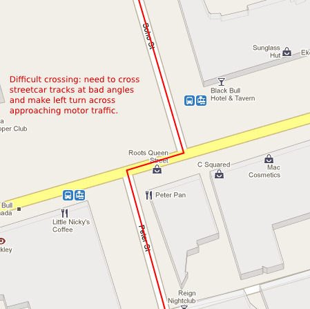
Peter/Soho crossing at Queen Street West
Looking south where Soho meets Queen Street West and the jog to Peter with lights
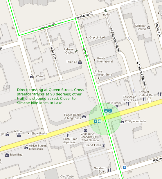
John Street, on the other hand has a direct crossing over Queen. No fuss.
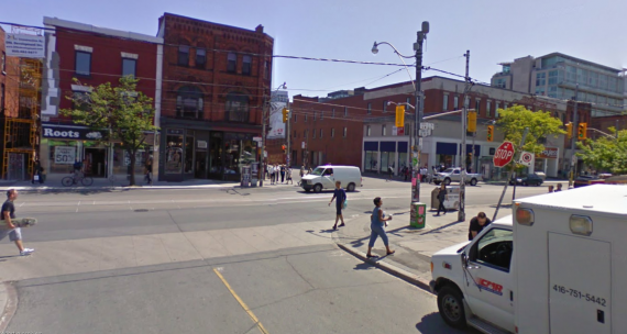
Where John crosses Queen Street West
Some attempts have been made to make a Peter Street alternative workable, but this would still take some political will to make the crossing safer. Meanwhile John Street already works - why make it worse for cyclists?
Peter Street then turns into Blue Jay Way and south of Front Street it turns into a steep hill up and around the Rogers Centre. It's not intuitive that this route would be a good cycling route; it's windy and steep. For cyclists who want a quick route to the Lake, this would not come to mind. Instead most cyclists now probably take Simcoe, Bay or Yonge (and avoiding Spadina).
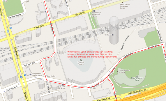
Proposed route up and around Blue Jay Way, Navy Wharf, and Bremner
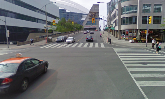
Looking South up hill at Blue Jay Way and Front
Let's make a comparative overview of the two presented options:
| Beverley/Soho/Peter/Blue Jays Way/Bremner | Beverley/John/Richmond/Simcoe |
|---|---|
| 4 turns | 2 turns |
| 4 traffic controls | 3 traffic controls |
| Requires contra-flow on Phoebe and Soho | Requires contra-flow on Stephanie |
| Requires reconfiguring Queen and Peter intersection | Requires no reconfiguration at John and Queen |
| Forces cyclists up steep hill | No noticeable grade |
| Windy route around Rogers Centre | Short jog to Simcoe |
In my mind, the left turns across streetcar tracks at Soho/Peter is a deal-breaker. The intersection doesn't come off all that well in other areas either.
Cultural Corridor Argument
None of the recommended redesigns of John Street included bike lanes. The impetus for the redesign was to recognize John as a "cultural corridor". Why does there seem to be no space, either physically or culturally, for bikes? When NYC reconfigured Broadway and Time's Square to make them pedestrian friendly they also accommodated cyclists in the plan by building in protected bike lanes. Why is this not possible for John?
Councillor Vaughan has made it clear in a letter to his constituents, however, that he prefers bike lanes that take Peter Street rather than John. I think otherwise: Peter Street is an inferior choice to John.
Planning a connected network rather than isolated patches
Vaughan and the report on John Street focus on the current relative mode share of John Street by pedestrians, cyclists and motorists. They use the statistic that only 2% of users are cyclists and there are far more pedestrians, leading to the conclusion that pedestrians will be pre-eminent in planning the street. In my previous post I demonstrated how inconsistencies and possible errors were found in using this measure.
Even if we took 2% at face value, it is not the relative use of the section of John Street that is relevant here; it is the number of cyclists that use John in comparison of all of the cyclists on other streets. That is, it's the importance of John Street to cyclists as they travel north/south. (That 2% supports one of the biggest bicycle shops in the city, Urbane Cyclist and supporter of bike lanes on John.) The statistic underplays how important the street is to cyclists.
It is the importance of John to cyclists that should be considered not the relative usage of John Street between various users. We can't evaluate the traffic importance of John Street in isolation. The Rosedale subway station has very few passengers; should we remove that section of the Yonge Street subway and make it discontinuous? It is the most important north south section of street in the city the numbers of cyclists are high just not in comparison to the total number of pedestrians on the street.
Planning needs to be done city wide not street by street.
Flawed EA Process
The Environmental Assessment process for the John Street Pedestrian Plaza sought comments from the public in June of 2010. None of the 5 preferred options identified, and to be considered, by the EA process included protected bicycle lanes on John Street. The highest number of comments by the public, however, addressed the need for better cycling facilities. How did this mismatch happen?
The failure to include protected bicycle lanes is a failure to acknowledge the existing importance of John Street to cyclists. One could at least understand this position if the City was trying to create a new function for the street to include cycling when it wasn’t there before but not where we already have one of the most important links in the City.
Vaughan told cyclists in emails in June and July, 2010 just after the Environmental Assessment process had started but nowhere near completed that he was opposed to protected bike lanes on John Street because of the “cultural values” of the John Street pedestrian plaza. Why was Councillor Vaughan taking a position on the EA process even before it reached conclusions? What would he do if it concluded that bike lanes could be accommodated, or that they would be a useful addition?
The funding for the design EA process is coming from the John Street Business Improvement Association (John Street BIA). Two of the largest financial supporters of the plaza are probably the two largest employers on the street, CityTV and TIFF. Are we seeing a repeat of the Bloor Yorkville BIA exclusion of bike lanes? Where local business interests are prioritized over other users of the street? Will we see another street marginalize cyclists with no dedicated space on the road? With bad bike parking?
John Street compromise for protected bike lanes
Councillor Vaughan wants a pedestrian plaza on John Street (or at least one that still allows cars). He can still create a street that greatly enhances the pedestrian realm but also accommodates cyclists safely. The proposed network by Councillor Denzil Minnan-Wong and the Bike Union, however, makes a compromise. The bike lanes need only travel from Stephanie, one block north of Queen down to Richmond Street - just two blocks. All of the rest of John Street would be available for a pedestrian plaza without bicycle lanes from Richmond to King Street or Front Street. Just so long that cyclists can easily get to the proposed bike lanes on Richmond Street.
As a cultural corridor, the plan is to make it easier to close off John Street for special events and concerts. But why can’t we have a John Street that is closed occasionally and still includes dedicated bike lanes that are also closed at the same time? If roads can be closed for cars during special events, they can be closed for bicycles as well. Yonge Street closes for Pride, University closes for the Santa Claus parade and so on.
We can fit bike lanes and still improve the pedestrian realm
The project managers for the John Street EA have stated that all their design options will "accommodate" cyclists. Their definition of accommodating cyclists, however, means cars and bikes will "share the road". Their definition is so broad that it includes all Toronto streets other than the Gardiner, DVP and 400 series highways.
Actually John Street has enough width to widen the sidewalk and install bike lanes on all sections of the street except for the block north of Queen Street, and even there bike lanes would have minimal impact on the pedestrian realm (source: Bike Union):
- Stephanie Street to Queen Street block - with bike lanes, sidewalks would be reduced by 1.6metres. However, the existing sidewalk width is already 13.5metres!
- Queen Street to Richmond Street block - with bike lanes, sidewalks could still be widened by 1.2metres
- Richmond Street to Adelaide Street block - with bike lanes, sidewalks could still be widened by 1.2metres
- Adelaide Street to King Street block - with bike lanes, sidewalks could still be widened by 3.8metres
- King Street to Wellington Street block - with bike lanes, sidewalks could still be widened by 3.8metres
- Wellington Street to Front Street block - with bike lanes, sidewalks could still be widened by 3.8metres
I hope this has made a convincing enough case for the City to reconsider their preferred options for John Street. I, the Bike Union and others are asking them to take it seriously that bikes belong on John; and that it is a major key in the bikeway network. Please put in your calendar that there will be a public open house to learn more about and comment on the City's project seeking to improve the public realm of John Street. Thursday, June 16, 2011 6:30 - 8:30 p.m. Room 309, Metro Hall 55 John Street.
This meeting will give you the chance to review the evaluation of various alternative designs for John Street and provide feedback on them. All comments received by June 30 will be considered by the Project Team in finalizing the project's recommendations and Environmental Study Report.
Here's the list of current organizations and groups supporting the protected bike lane proposal:
South Rosedale Residents Association, Curbside Cycle , The Toronto Cyclists Union, the Moore Park Residents Association , Mountain Equipment Co-op (700,000 members in the GTA) , the York Quay Neighbourhood Association, The Palmerston Residents Association , the Parkdale Residents Association, Toronto Island Community Association, The Bay Cloverhill Residents Association, The University of Toronto Graduate Student’s Union, the St Lawrence Neighbourhood Association, the Oak Street Housing Coop Inc. and the ABC(Yorkville) Residents Association.


